Showing posts with label Applications in GIS. Show all posts
Showing posts with label Applications in GIS. Show all posts
Thursday, August 6, 2020
Damage Assessment
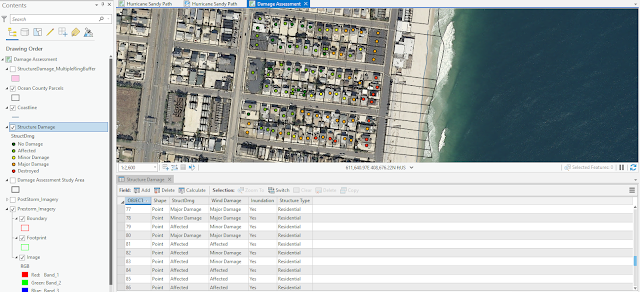
For this week's module, we finished our damage assessment on Hurricane Sandy. We were tasked with categorizing and counting the amount of structure damage caused to buildings in a study area in Ocean County, NJ. This was done by analyzing a pre-storm aerial and a post-storm aerial to determine the amount of damage that occurred in accordance to distance from the shoreline. It was simple to determine homes with major damage or destroyed but it was much trickier to discern between minor damage, affected, and no damage without having the benefit of street view images. A county parcel was used to ensure a structure was digitized in every parcel. After the attributes for the storm damage were added, I changed the symbology to unique values to assign a continuous color ramp to the symbols with labels. To determine the type and number of structural damage caused every 100 meters from the storm, I used the Multi Ring Buffer geoprocessing tool. Fortunately, every building fit entirely inside a buffer ring. This part of the analysis showed that the amount of damage decreased every 100 meters.
Sunday, July 26, 2020
Crime Analysis
Module 4 explored using hotspot mapping for crime analysis. We learned how to aggregate crime events to determine crime rates and practiced the use of local and global spatial clustering methods. We also examined spatial patterns in crime rates and socio-economic characteristics. Three hotpot mapping techniques we used were grid based thematic, kernel density, and Local Moran's I. It was determined that the best hotspot mapping technique for police departments to use for predictive policing is kernel density.


The
Kernel Density map would be the best map for predicting future homicides
because it does more than just consider total households and total homicides or
even crime rate. It considers the density of homicides with relation to area
and the number of homicides and the output results in smaller, more focused
clusters.
Subscribe to:
Posts (Atom)

